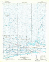
1934 Map of Johnsons Bayou
USGS Topo · Published 1970About this map
Smith Ridge and Coon Ridge rise above the marshy wetlands of southwestern Louisiana, anchoring a landscape shaped by intricate tidal waterways and early industrial drainage. Surveyed in 1934, the map reveals a remote coastal community centered around Johnsons Bayou Sch and the nearby Pevoto Cemetery. The hydrology of the area is defined by natural features like Deep Bayou and Junius Ridge Bayou, alongside man-made interventions such as the Starks Canal and the Magnolia-Vacuum Canal, which hint at the region's developing oil and navigation interests. This era captures the Cameron Parish shoreline along the Gulf of Mexico before significant modern coastal erosion, showing the placement of family settlements and schools on the slightly elevated cheniers that provided stable ground for residents.
Find a feature on this map
21 named features on this map. Tap any name to fly to it.
Don’t see what you’re looking for? This feature index may not catch every label — zoom into the map to look around manually.
Map Details
Editions of this 1934 Johnsons Bayou Map
3 editions found
Other maps of this area

1932 · Sabine Pass NE
USGS Topo · 1:31,680

1932 · Port Arthur NE
USGS Topo · 1:31,680

1934 · Johnsons Bayou
USGS Topo · 1:24,000

1934 · Peveto Beach
USGS Topo · 1:24,000

1934 · Greens Bayou
USGS Topo · 1:24,000

1934 · Five Lakes
USGS Topo · 1:24,000

1935 · Peveto Beach
USGS Topo · 1:31,680

1935 · Five Lakes
USGS Topo · 1:31,680

1935 · Greens Bayou
USGS Topo · 1:31,680

1935 · Johnsons Bayou
USGS Topo · 1:31,680