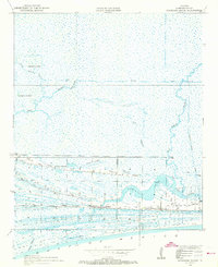
1934 Map of Johnsons Bayou
USGS Topo · Published 1973About this map
The coastal marshlands of Cameron Parish are defined by an intricate network of waterways and elevated cheniers in this 1934 survey. Smith Ridge and Junius Ridge provide narrow corridors of higher ground amidst the expansive wetlands, supporting the community infrastructure of the era. The settlement is centered around the Johnsons Bayou PO BM and the Johnsons Bayou Sch, showing a remote coastal society tied to the landscape. To the north, the geography is dominated by complex drainage systems including Bayou Junius, Deep Bayou, and Double Island Gully, which snake through the marsh toward Hamilton Lake. The map also documents industrial and cultural markers, from the Magnolia Vacuum Canal to the isolated Pevoto Cemetery, capturing the balance between maritime industry and local family history along the Louisiana coast.
Find a feature on this map
21 named features on this map. Tap any name to fly to it.
Don’t see what you’re looking for? This feature index may not catch every label — zoom into the map to look around manually.
Map Details
Editions of this 1934 Johnsons Bayou Map
3 editions found
Other maps of this area

1932 · Sabine Pass NE
USGS Topo · 1:31,680

1932 · Port Arthur NE
USGS Topo · 1:31,680

1934 · Johnsons Bayou
USGS Topo · 1:24,000

1934 · Peveto Beach
USGS Topo · 1:24,000

1934 · Greens Bayou
USGS Topo · 1:24,000

1934 · Five Lakes
USGS Topo · 1:24,000

1935 · Peveto Beach
USGS Topo · 1:31,680

1935 · Five Lakes
USGS Topo · 1:31,680

1935 · Greens Bayou
USGS Topo · 1:31,680

1935 · Johnsons Bayou
USGS Topo · 1:31,680