
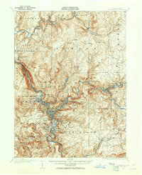
1904 Map of Johnstown
USGS Topo · Published 1954About this map
Johnstown and its satellite industrial boroughs are captured here at the start of the twentieth century, anchored by the confluence of Stony Creek and the Little Conemaugh River. The map shows a landscape dominated by the steel and coal economy, where neighborhoods like Morrellville, Franklin, and Woodvale are densely packed alongside the Pennsylvania RR corridors. On the hills above the river valley, the sprawling Grandview Cemetery overlooks the city, providing a significant touchstone for genealogical research in the region.
Find a feature on this map
96 named features on this map. Tap any name to fly to it.
Don’t see what you’re looking for? This feature index may not catch every label — zoom into the map to look around manually.
Map Details
Editions of this 1904 Johnstown Map
2 editions found
Other maps of this area

1902 · Indiana
USGS Topo · 1:62,500

1902 · Ebensburg
USGS Topo · 1:62,500

1902 · Patton
USGS Topo · 1:62,500

1902 · Barnesboro
USGS Topo · 1:62,500

1904 · Barnesboro
USGS Topo · 1:62,500

1904 · Patton
USGS Topo · 1:62,500

1904 · Ebensburg
USGS Topo · 1:62,500

1907 · Johnstown
USGS Topo · 1:62,500

1908 · Bedford
USGS Topo · 1:62,500

1910 · Bedford
USGS Topo · 1:62,500