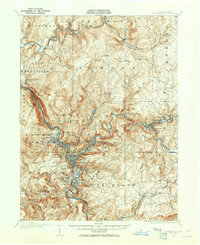
1904 Map of Johnstown
USGS Topo · Published 1965About this map
Johnstown serves as the industrial and logistical heart of this 1904 survey, situated at the confluence of the Conemaugh River and Stony Creek. The map documents a landscape defined by heavy transit infrastructure, including the Pennsylvania RR and the Pittsburgh Grade, which navigate the deep valleys of the Laurel Hill region. Evidence of earlier engineering is preserved in the Old Portage RR Tunnel, a remnant of the historic main line that once connected the Susquehanna and Ohio river basins. Outside the main urban center, residential and industrial pockets like Morrellville, Cambria, and Franklin reflect the dense development of the iron and steel era. To the north and east, the terrain transitions into a network of small mining and railroad towns such as Vintondale and South Fork, while the Philadelphia and Pittsburgh Turnpike follows the high ridges, providing a glimpse into the overland travel patterns of the nineteenth century.
Find a feature on this map
95 named features on this map. Tap any name to fly to it.
Don’t see what you’re looking for? This feature index may not catch every label — zoom into the map to look around manually.
Map Details
Editions of this 1904 Johnstown Map
2 editions found
Other maps of this area

1902 · Indiana
USGS Topo · 1:62,500

1902 · Ebensburg
USGS Topo · 1:62,500

1902 · Patton
USGS Topo · 1:62,500

1902 · Barnesboro
USGS Topo · 1:62,500

1904 · Barnesboro
USGS Topo · 1:62,500

1904 · Patton
USGS Topo · 1:62,500

1904 · Ebensburg
USGS Topo · 1:62,500

1904 · Johnstown
USGS Topo · 1:62,500

1907 · Johnstown
USGS Topo · 1:62,500

1908 · Bedford
USGS Topo · 1:62,500