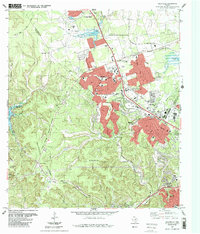
1987 Map of Jollyville
USGS Topo · Published 1987About this map
Jollyville Plateau serves as the topographic foundation for this 1980s look at the rapid suburbanization north of Austin. The map captures a moment of significant transition where traditional landmarks like the Pond Springs Cem and Oak Grove Ch stand adjacent to burgeoning residential developments and modern campuses such as Westwood High Sch. The intersection of nature and infrastructure is evident along Bull Creek and Cypress Creek, where established parks like Cypress Creek County Park and Bull Creek District Park provide a buffer against the expanding street networks of Cedar Park and Jollyville. The Southern Pacific rail line cuts through the northern landscape, passing the Leander Rehabilitation Center, while the Capitol of Texas Highway anchors the southern transit corridor through the hills.
Find a feature on this map
49 named features on this map. Tap any name to fly to it.
Don’t see what you’re looking for? This feature index may not catch every label — zoom into the map to look around manually.
Map Details
Editions of this 1987 Jollyville Map
This is the sole edition of this map. No revisions or reprints were ever made.
Other maps of this area

1893 · Georgetown
USGS Topo · 1:125,000

1896 · Austin
USGS Topo · 1:125,000

1897 · Austin
USGS Topo · 1:125,000

1910 · Austin
USGS Topo · 1:125,000

1928 · Round Rock
USGS Topo · 1:62,500

1930 · Austin-2
USGS Topo · 1:48,000

1932 · Mt. Bonnell
USGS Topo · 1:62,500

1949 · Round Rock
USGS Topo · 1:62,500

1951 · Round Rock
USGS Topo · 1:62,500

1954 · Austin East
USGS Topo · 1:24,000