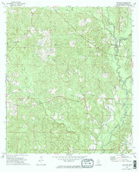
1973 Map of Jonathan
USGS Topo · Published 1974About this map
The Leaf River winds through the eastern edge of this landscape, carving a valley defined by numerous tributaries like Mason Branch and Deep Br. In the early 1970s, this portion of Greene County was characterized by isolated settlements and a network of creeks. The small community of Jonathan sits near the river, while further west, Byrd and Bradley mark higher ground. Local landmarks such as the Greer Lookout Tower provided a vantage point over the pine-heavy terrain, reflecting the importance of fire observation in this rural timber-rich region.
Find a feature on this map
26 named features on this map. Tap any name to fly to it.
Don’t see what you’re looking for? This feature index may not catch every label — zoom into the map to look around manually.
Map Details
Editions of this 1973 Jonathan Map
2 editions found
Other maps of this area

1947 · Beaumont
USGS Topo · 1:62,500

1949 · Beaumont
USGS Topo · 1:62,500

1953 · Hattiesburg
USGS Topo · 1:250,000

1958 · Hattiesburg
USGS Topo · 1:250,000

1963 · Brewer
USGS Topo · 1:24,000

1964 · Clark
USGS Topo · 1:24,000

1964 · Avera
USGS Topo · 1:24,000

1972 · Leakesville
USGS Topo · 1:24,000
1972 · Vernal
USGS Topo · 1:24,000

1973 · Jonathan
USGS Topo · 1:24,000