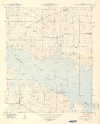
1950 Map of Jones Crossroads
USGS Topo · Published 1950About this map
Wheeler Reservoir dominates the landscape of this 1950 survey, where the Tennessee River channel carves between Limestone, Lawrence, and Morgan counties. The map captures the region's mid-century rural character, defined by family-named cemeteries and community landmarks like Mason Cem, Bethlehem Cem, and Murphy Cem. The presence of Browns Ferry on the river's north bank indicates the importance of old river crossings, even as the Joe Wheeler Highway and Huntsville Road provided modernized overland access to settlements like Lawngate and Proctor. For genealogists, the map is particularly rich in religious and educational sites, including Oak Grove Ch, St Lawrence Church, and the Wheeler Sch, many of which served the small communities clustered around Jones Crossroads and Beulah Land.
Find a feature on this map
46 named features on this map. Tap any name to fly to it.
Don’t see what you’re looking for? This feature index may not catch every label — zoom into the map to look around manually.
Map Details
Editions of this 1950 Jones Crossroads Map
3 editions found
Other maps of this area

1888 · Huntsville
USGS Topo · 1:125,000

1892 · Huntsville
USGS Topo · 1:125,000

1935 · Athens
USGS Topo · 1:24,000

1936 · Caddo
USGS Topo · 1:24,000

1936 · Decatur
USGS Topo · 1:24,000

1936 · Stewart Cross Roads
USGS Topo · 1:24,000

1936 · Ripley
USGS Topo · 1:24,000

1936 · Trinity
USGS Topo · 1:24,000

1936 · Hillsboro
USGS Topo · 1:24,000

1936 · Tanner
USGS Topo · 1:24,000