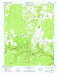
1949 Map of Jones Knob
USGS Topo · Published 1976About this map
The Cumberland Plateau landscape of the mid-1940s is defined by the high ridge of the Tennessee Divide and the deep incisions of Big Hollow and Cross Hollow. This era of the plateau shows a network of small, rural settlements including Banner Springs, Roslin, and Jonesville, many centered around local institutions like Springs Chapel and the Roslin Sch. The rugged topography is etched with numerous family-named crossings and landmarks, such as Ashburn Ford and Jones Ford, which speak to the traditional travel patterns before modern infrastructure dominated the region.
Find a feature on this map
56 named features on this map. Tap any name to fly to it.
Don’t see what you’re looking for? This feature index may not catch every label — zoom into the map to look around manually.
Map Details
Editions of this 1949 Jones Knob Map
3 editions found
Other maps of this area

1895 · Wartburg
USGS Topo · 1:125,000

1896 · Wartburg
USGS Topo · 1:125,000

1897 · Standingstone
USGS Topo · 1:125,000

1898 · Standingstone
USGS Topo · 1:125,000

1935 · Isoline
USGS Topo · 1:24,000

1935 · Clarkrange
USGS Topo · 1:24,000

1936 · Hebbertsburg
USGS Topo · 1:24,000

1936 · Fox Creek
USGS Topo · 1:24,000

1936 · Twin Bridges
USGS Topo · 1:24,000

1936 · Jones Knob
USGS Topo · 1:24,000