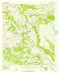
1956 Map of Jonesboro
USGS Topo · Published 1957About this map
The Leon River meanders through the heart of this Central Texas landscape, defining a region where the borders of Hamilton, Bosque, and Coryell counties meet. In the mid-1950s, the community of Jonesboro served as a local hub along the Division Memorial Highway, surrounded by smaller settlements like Pancake and Levita. The map preserves the traces of earlier transportation and education, notably the Old Railroad Grade running parallel to Plum Creek and the Stanford School located near Middle Fork Valley Creek. Rural life is etched into the terrain through numerous family and community sites, from the Willy Grubb Cem and Viertel Cem to local spiritual centers like Bethel Ch and Pleasant Valley Ch. To the north, the elevation rises toward High Point and Cutoff Mtn, while the southern reaches are marked by essential infrastructure like a Power Sta near Ames.
Find a feature on this map
53 named features on this map. Tap any name to fly to it.
Don’t see what you’re looking for? This feature index may not catch every label — zoom into the map to look around manually.
Map Details
Editions of this 1956 Jonesboro Map
This is the sole edition of this map. No revisions or reprints were ever made.
Other maps of this area

1887 · Lampasas
USGS Topo · 1:125,000

1888 · Hamilton
USGS Topo · 1:125,000

1888 · Meridian
USGS Topo · 1:125,000

1894 · Hamilton
USGS Topo · 1:125,000

1894 · Meridian
USGS Topo · 1:125,000

1894 · Lampasas
USGS Topo · 1:125,000

1894 · Gatesville
USGS Topo · 1:125,000

1947 · Purmela
USGS Topo · 1:62,500

1947 · Gatesville West
USGS Topo · 1:24,000

1947 · Purmela
USGS Topo · 1:24,000