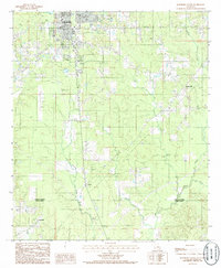
1985 Map of Jonesboro South
USGS Topo · Published 1986About this map
The southern outskirts of Jonesboro serve as the anchor for this mid-1980s landscape, where industrial infrastructure meets the dense drainage networks of north-central Louisiana. The topography is defined by the transition from the town's developed areas, featuring the Lookout Tower Jonesboro and a local Airport, into the timbered terrain of the Jackson Parish and Winn Parish border. Significant watercourses like Antwine Creek and Garrett Creek carve through the region, illustrating the importance of natural drainage to the local geography.
Find a feature on this map
19 named features on this map. Tap any name to fly to it.
Don’t see what you’re looking for? This feature index may not catch every label — zoom into the map to look around manually.
Map Details
Editions of this 1985 Jonesboro South Map
This is the sole edition of this map. No revisions or reprints were ever made.
Other maps of this area

1947 · Goldonna
USGS Topo · 1:62,500

1947 · Bienville
USGS Topo · 1:62,500

1949 · Bienville
USGS Topo · 1:62,500

1949 · Jonesboro
USGS Topo · 1:62,500

1950 · Jonesboro
USGS Topo · 1:62,500

1953 · Hodge
USGS Topo · 1:62,500

1955 · Shreveport
USGS Topo · 1:250,000

1956 · Shreveport
USGS Topo · 1:250,000

1957 · Goldonna
USGS Topo · 1:62,500

1984 · Shreveport
USGS Topo · 1:250,000