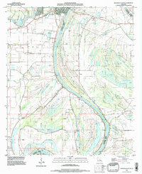
1994 Map of Jonesboro South
USGS Topo · Published 1997About this map
The Black River meanders through the heart of this delta landscape, serving as a defining border between Catahoula Parish and Concordia Parish. The confluence of the Little River and Black River near Jonesville anchors the northern region, where levees and a road on levee manage the seasonal cycles of the surrounding bottomlands. The terrain is characterized by a complex network of brakes and lakes, such as Duck Roost Lake, Simpson Brake, and Gin Lake, which illustrate the hydraulic history of the Mississippi River floodplain. Industrial activity is prominent in the form of several energy operations, including the Willow Lake Oil Field and the California Bayou Oil Field. For those tracing local history, the map provides precise locations for numerous rural burial grounds like St Mary Cem, Pollard Cem, and Wilson Cem, alongside small riverfront communities like Security and Lismore.
Find a feature on this map
66 named features on this map. Tap any name to fly to it.
Don’t see what you’re looking for? This feature index may not catch every label — zoom into the map to look around manually.
Map Details
Editions of this 1994 Jonesboro South Map
This is the sole edition of this map. No revisions or reprints were ever made.
Other maps of this area

1947 · Goldonna
USGS Topo · 1:62,500

1947 · Bienville
USGS Topo · 1:62,500

1949 · Bienville
USGS Topo · 1:62,500

1949 · Jonesboro
USGS Topo · 1:62,500

1950 · Jonesboro
USGS Topo · 1:62,500

1953 · Hodge
USGS Topo · 1:62,500

1955 · Shreveport
USGS Topo · 1:250,000

1956 · Shreveport
USGS Topo · 1:250,000

1957 · Goldonna
USGS Topo · 1:62,500

1984 · Shreveport
USGS Topo · 1:250,000