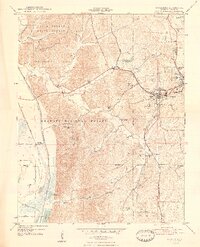
1948 Map of Jonesboro
USGS Topo · Published 1948About this map
The neighboring hubs of Anna and Jonesboro anchor this Southern Illinois landscape, where the Illinois Central and Gulf Mobile and Ohio railroads converge to move goods through the region. To the west, the rugged topography of the Union County State Forest and Shawnee National Forest dominates, marked by landmarks such as Atwood Ridge and the Atwood Lookout Tower.
Find a feature on this map
44 named features on this map. Tap any name to fly to it.
Don’t see what you’re looking for? This feature index may not catch every label — zoom into the map to look around manually.
Map Details
Editions of this 1948 Jonesboro Map
4 editions found
Other maps of this area

1920 · Jonesboro
USGS Topo · 1:62,500

1920 · Dongola
USGS Topo · 1:62,500

1922 · Carbondale
USGS Topo · 1:62,500

1923 · Dongola
USGS Topo · 1:62,500

1923 · Jonesboro
USGS Topo · 1:62,500

1924 · Alto Pass
USGS Topo · 1:62,500

1941 · Carbondale
USGS Topo · 1:62,500

1947 · Jonesboro
USGS Topo · 1:62,500

1947 · Alto Pass
USGS Topo · 1:62,500

1947 · Mc Clure
USGS Topo · 1:24,000