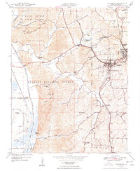
1948 Map of Jonesboro
USGS Topo · Published 1948About this map
Jonesboro and neighboring Anna serve as the primary hubs in this late 1940s landscape, positioned at the convergence of the Gulf Mobile and Ohio and Illinois Central railroads. The topography transitions from the managed timberlands of the Union County State Forest and Shawnee National Forest to the productive bottomlands of the Clear Creek Ditch system.
Find a feature on this map
52 named features on this map. Tap any name to fly to it.
Don’t see what you’re looking for? This feature index may not catch every label — zoom into the map to look around manually.
Map Details
Editions of this 1948 Jonesboro Map
4 editions found
Other maps of this area

1920 · Jonesboro
USGS Topo · 1:62,500

1920 · Dongola
USGS Topo · 1:62,500

1922 · Carbondale
USGS Topo · 1:62,500

1923 · Dongola
USGS Topo · 1:62,500

1923 · Jonesboro
USGS Topo · 1:62,500

1924 · Alto Pass
USGS Topo · 1:62,500

1941 · Carbondale
USGS Topo · 1:62,500

1947 · Jonesboro
USGS Topo · 1:62,500

1947 · Alto Pass
USGS Topo · 1:62,500

1947 · Mc Clure
USGS Topo · 1:24,000