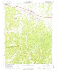
1973 Map of Jonesburg
USGS Topo · Published 1975About this map
Jonesburg and High Hill anchor the northern landscape of this survey, situated along the Norfolk and Western rail corridor that traverses the divide between Bear Creek and the southern hollows. The area is characterized by a dense network of family-named drainages and ridges, including Donahue Hollow, Greyham Hollow, and Gore Ridge, reflecting long-standing rural settlement patterns. In the south, the Daniel Boone Memorial State Forest encompasses significant terrain near Jordan Hollow and Camp Sandy Hollow. Economic activity of the 1970s is evidenced by several claypits and a quarry, indicating the local importance of mineral extraction alongside traditional timber and agriculture. Genealogists will find several burial sites preserved on the landscape, such as Bolton Cem and Coleman Cem, which mark the history of the early township residents.
Find a feature on this map
56 named features on this map. Tap any name to fly to it.
Don’t see what you’re looking for? This feature index may not catch every label — zoom into the map to look around manually.
Map Details
Editions of this 1973 Jonesburg Map
2 editions found
Other maps of this area

1890 · Hermann
USGS Topo · 1:125,000

1936 · Hermann
USGS Topo · 1:48,000

1942 · Hermann
USGS Topo · 1:62,500

1942 · New Florence
USGS Topo · 1:62,500

1943 · Warrenton
USGS Topo · 1:62,500

1945 · Hermann
USGS Topo · 1:62,500

1945 · Warrenton
USGS Topo · 1:62,500

1946 · New Florence
USGS Topo · 1:62,500

1948 · Washington
USGS Topo · 1:62,500

1949 · Saint Louis
USGS Topo · 1:250,000