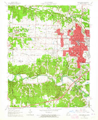
1962 Map of Joplin West
USGS Topo · Published 1964About this map
Joplin anchors this early 1960s survey, showing its westward expansion toward the Kansas state line alongside a landscape deeply marked by its mining heritage. Numerous Tailings piles and old pits surround the former mining camp of Chitwood and the vicinity of Central City, reflecting the intensive lead and zinc extraction that once drove the local economy. The urban grid is dense with civic infrastructure, featuring a notable concentration of educational and religious institutions including Columbia School, McAuley High School, and the Ozark Bible College. To the south, the terrain descends toward the winding Shoal Creek, where the community of Redings Mill sits near the namesake landmark. Transportation corridors like the Missouri - Kansas - Texas Railroad and the St Louis - San Francisco Railroad define the industrial and transit patterns of the era, while extensive green spaces like Schifferdecker Park provide a recreational counterpoint to the town's industrial and residential core.
Find a feature on this map
77 named features on this map. Tap any name to fly to it.
Don’t see what you’re looking for? This feature index may not catch every label — zoom into the map to look around manually.
Map Details
Editions of this 1962 Joplin West Map
2 editions found
Other maps of this area

1886 · Joplin
USGS Topo · 1:125,000

1886 · Carthage
USGS Topo · 1:125,000

1894 · Joplin
USGS Topo · 1:125,000

1894 · Carthage
USGS Topo · 1:125,000

1907 · Wyandotte
USGS Topo · 1:125,000

1909 · Wyandotte
USGS Topo · 1:125,000

1916 · Neosho
USGS Topo · 1:62,500

1947 · Joplin
USGS Topo · 1:250,000

1949 · Joplin
USGS Topo · 1:250,000

1949 · Racine
USGS Topo · 1:24,000