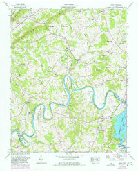
1961 Map of Joppa
USGS Topo · Published 1977About this map
Indian Cave and the winding coils of the Holston River dominate this 1961 landscape in East Tennessee. The river carves dramatic oxbows such as Mule Shoe Bend and Horse Shoe Bend, creating isolated landforms like Gilmore Island and Smoky Island. The presence of Massengill Mill and the Buffalo Springs Game Farm illustrates a rural economy balanced between early industry and land management.
Find a feature on this map
73 named features on this map. Tap any name to fly to it.
Don’t see what you’re looking for? This feature index may not catch every label — zoom into the map to look around manually.
Map Details
Editions of this 1961 Joppa Map
3 editions found
Other maps of this area

1883 · Morristown
USGS Topo · 1:125,000

1893 · Morristown
USGS Topo · 1:125,000

1895 · Morristown
USGS Topo · 1:125,000

1897 · Maynardville
USGS Topo · 1:125,000

1900 · Maynardville
USGS Topo · 1:125,000

1935 · Luttrell
USGS Topo · 1:24,000

1935 · Mascot
USGS Topo · 1:24,000

1935 · Tate Springs
USGS Topo · 1:48,000

1935 · Straw Plains
USGS Topo · 1:48,000

1935 · Joppa
USGS Topo · 1:24,000