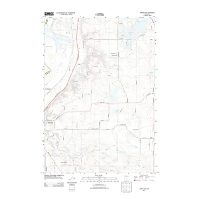
2013 Map of Jordan East
USGS Topo · Published 2013About this map
The Minnesota River corridor and its low-lying marshes dominate the western edge of this Scott County landscape, characterized by the Louisville Swamp and Johnson Slough. Inland from the river, the terrain rises into the Ridges of Sand Creek, where the city of Jordan and smaller settlements like Saint Josephs and Marystown are situated. This area showcases a mix of agricultural tradition and early 21st-century rural living, evidenced by landmarks like Jim's Apple Farm and the Sky Park Airport. Local history is preserved at Saint Marys Cem and Calvary Cem, while the natural topography is defined by numerous glacial water bodies, including Thole Lake, Geis Lake, and Sutton Lake. Small crossroads communities such as Merriam, Baden, and Lydia illustrate the dispersed settlement pattern that has persisted east of the river valley.
Find a feature on this map
84 named features on this map. Tap any name to fly to it.
Don’t see what you’re looking for? This feature index may not catch every label — zoom into the map to look around manually.
Map Details
Editions of this 2013 Jordan East Map
This is the sole edition of this map. No revisions or reprints were ever made.
Other maps of this area

1896 · Minneapolis
USGS Topo · 1:62,500

1901 · Minneapolis
USGS Topo · 1:62,500

1905 · Minnetonka
USGS Topo · 1:62,500

1907 · Minnetonka
USGS Topo · 1:62,500

1953 · Saint Paul
USGS Topo · 1:250,000

1954 · Eden Prairie
USGS Topo · 1:24,000

1954 · Minneapolis
USGS Topo · 1:62,500

1957 · Prior Lake
USGS Topo · 1:62,500

1957 · New Prague
USGS Topo · 1:62,500

1958 · Victoria
USGS Topo · 1:24,000