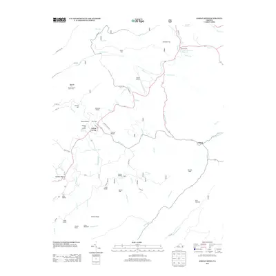
2013 Map of Jordan Mines
USGS Topo · Published 2013About this map
Jordan Mines and the surrounding Alleghany County landscape are defined by a complex network of ridges and hollows drained by Potts Cr and its many tributaries. This 2013 survey illustrates a region where industrial history and natural features intersect, from the high elevation of Morning Knob—site of the Morning Knob Fire Lookout Tower—to the lower flats of Moores Bottom and The Sinks. The map highlights several localized settlements including Boiling Spring and Clifdale, which are linked by narrow mountain roads like Crowder Hollow Rd and The Grade.
Find a feature on this map
65 named features on this map. Tap any name to fly to it.
Don’t see what you’re looking for? This feature index may not catch every label — zoom into the map to look around manually.
Map Details
Editions of this 2013 Jordan Mines Map
This is the sole edition of this map. No revisions or reprints were ever made.
Other maps of this area

1887 · Lewisburg
USGS Topo · 1:125,000

1891 · Lewisburg
USGS Topo · 1:125,000

1894 · Natural Bridge
USGS Topo · 1:125,000

1913 · Eagle Rock
USGS Topo · 1:48,000

1915 · Eagle Rock
USGS Topo · 1:62,500

1921 · Callaghan
USGS Topo · 1:48,000

1923 · Callaghan
USGS Topo · 1:62,500

1945 · Clifton Forge
USGS Topo · 1:62,500
1945 · New Castle
USGS Topo · 1:62,500
1946 · Callaghan
USGS Topo · 1:62,500