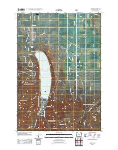
2011 Map of Joseph
USGS Topo · Published 2011About this map
Wallowa Lake dominates the southern landscape of this 2011 survey, framed by the steep rise of Chief Joseph Mountain and Mount Howard. At the northern foot of the lake, the town of Joseph serves as the local hub, its grid defined by landmarks like the Joseph Post Office and the Joseph Cemetery. This area reflects a complex water management system essential for mountain valley life, illustrated by the Wallowa Lake Dam and a network of irrigation channels including Farmers Ditch, Granger Ditch, and Wrenn Dobbin Ditch.
Find a feature on this map
70 named features on this map. Tap any name to fly to it.
Don’t see what you’re looking for? This feature index may not catch every label — zoom into the map to look around manually.
Map Details
Editions of this 2011 Joseph Map
This is the sole edition of this map. No revisions or reprints were ever made.
Other maps of this area

1954 · Cornucopia
USGS Topo · 1:62,500

1954 · Eagle Cap
USGS Topo · 1:62,500

1955 · Grangeville
USGS Topo · 1:250,000

1957 · Enterprise
USGS Topo · 1:62,500

1957 · Joseph
USGS Topo · 1:62,500

1959 · Grangeville
USGS Topo · 1:250,000

1986 · Enterprise
USGS Topo · 1:100,000

1990 · Chief Joseph Mtn
USGS Topo · 1:24,000
1990 · Eagle Cap
USGS Topo · 1:24,000
1990 · Joseph
USGS Topo · 1:24,000