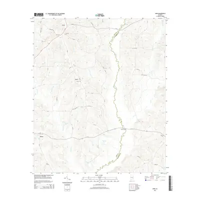
2014 Map of Josie
USGS Topo · Published 2014About this map
The Pea River carves a sinuous path through this rural landscape on the border of Pike and Barbour Counties, serving as the central topographical feature for the surrounding communities. At the northern end of this corridor, Josie sits near the junction of Us-29 and several county routes, while the settlement of Enon remains anchored by the Enon Cem. The area is notably dense with small family or community burial sites, including the Old Ramah Cem and Sardis Cem, which provide significant points of interest for genealogical research in this part of Alabama.
Find a feature on this map
55 named features on this map. Tap any name to fly to it.
Don’t see what you’re looking for? This feature index may not catch every label — zoom into the map to look around manually.
Map Details
Editions of this 2014 Josie Map
This is the sole edition of this map. No revisions or reprints were ever made.
Other maps of this area

1948 · Brundidge
USGS Topo · 1:62,500

1950 · Brundidge
USGS Topo · 1:62,500

1953 · Dothan
USGS Topo · 1:250,000

1954 · Dothan
USGS Topo · 1:250,000

1955 · Dothan
USGS Topo · 1:250,000

1960 · Brundidge
USGS Topo · 1:24,000

1962 · Brundidge
USGS Topo · 1:25,000

1968 · Perote
USGS Topo · 1:24,000

1968 · Louisville
USGS Topo · 1:24,000
1968 · Saco
USGS Topo · 1:24,000