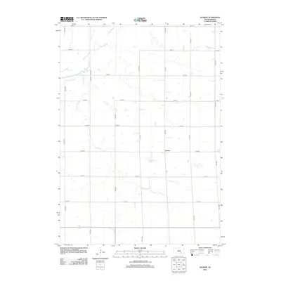
2012 Map of Joubert
USGS Topo · Published 2012About this map
Joubert stands as the primary namesake settlement in this section of Douglas County, characterized by a structured grid of rural section lines that define the agricultural landscape. The township is deeply intertwined with its local hydrology, centered around the Joubert Lake and the winding course of Platte Cr in the northwest. Several managed waterways, such as the Sluiter Drain and Meadow Drain, indicate a landscape modified for drainage and farming efficiency. These features, along with the E Fork Platte Cr, provide a clear picture of the region's reliance on the Platte Creek watershed. The network of numbered avenues and streets, including 372nd Ave and 268th St, illustrates the persistent township-and-range surveying system that has organized this South Dakota prairie for over a century.
Find a feature on this map
21 named features on this map. Tap any name to fly to it.
Don’t see what you’re looking for? This feature index may not catch every label — zoom into the map to look around manually.
Map Details
Editions of this 2012 Joubert Map
This is the sole edition of this map. No revisions or reprints were ever made.
Other maps of this area

1955 · Mitchell
USGS Topo · 1:250,000

1959 · Mitchell
USGS Topo · 1:250,000

1979 · Cedar Grove Colony
USGS Topo · 1:24,000
1979 · Bovee
USGS Topo · 1:24,000

1979 · Geddes SE
USGS Topo · 1:24,000
1979 · Geddes
USGS Topo · 1:24,000

1979 · New Holland
USGS Topo · 1:24,000

1979 · Laffey Lake
USGS Topo · 1:24,000

1979 · Aurora Center
USGS Topo · 1:24,000

1979 · Joubert
USGS Topo · 1:24,000