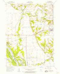
1953 Map of Joy
USGS Topo · Published 1958About this map
The Mississippi River floodplain and the winding Edwards River dominate this western Illinois landscape, where the Upper Mississippi River Wildlife and Fish Refuge covers the bottomlands and Corsépius Island. The map illustrates a mid-century rural economy tied to the rails, with the Chicago Burlington and Quincy line connecting the settlements of New Boston and Joy.
Find a feature on this map
32 named features on this map. Tap any name to fly to it.
Don’t see what you’re looking for? This feature index may not catch every label — zoom into the map to look around manually.
Map Details
Editions of this 1953 Joy Map
2 editions found
Other maps of this area

1916 · Edgington
USGS Topo · 1:62,500

1935 · Keithsburg
USGS Topo · 1:48,000

1938 · Edgington
USGS Topo · 1:62,500

1941 · Keithsburg
USGS Topo · 1:62,500

1946 · Wapello
USGS Topo · 1:62,500

1948 · Muscatine
USGS Topo · 1:62,500

1949 · Wapello
USGS Topo · 1:62,500

1953 · Toolesboro
USGS Topo · 1:24,000

1953 · Blanchard Island
USGS Topo · 1:24,000

1953 · Buffalo Prairie
USGS Topo · 1:24,000