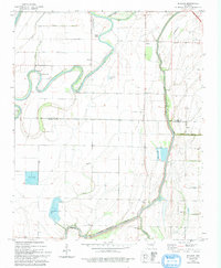
1974 Map of Joyland
USGS Topo · Published 1993About this map
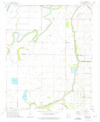
The St Francis River meanders sharply through the bottomlands of the Arkansas Delta in this early 1970s survey, defining the rural character of the border between Poinsett and Crittenden counties. The landscape is a complex network of engineered drainage, featuring Ditch No 1, Ditch No 44, and Bayou Mack, which support the region's agricultural production. Small settlements and spiritual centers are scattered across the terrain, from the community at Joyland to the cluster of churches further south, including New Hope Ch and Liberty Ch.
Find a feature on this map
33 named features on this map. Tap any name to fly to it.
Don’t see what you’re looking for? This feature index may not catch every label — zoom into the map to look around manually.
Map Details
Editions of this 1974 Joyland Map
2 editions found
Other maps of this area

1940 · Deckerville
USGS Topo · 1:62,500

1940 · Princedale
USGS Topo · 1:62,500

1940 · Dee
USGS Topo · 1:62,500

1941 · Marked Tree
USGS Topo · 1:62,500

1953 · Memphis
USGS Topo · 1:250,000

1956 · Marked Tree
USGS Topo · 1:62,500

1956 · Memphis
USGS Topo · 1:250,000

1956 · Princedale
USGS Topo · 1:62,500

1957 · Deckerville
USGS Topo · 1:62,500

1958 · Dee
USGS Topo · 1:62,500