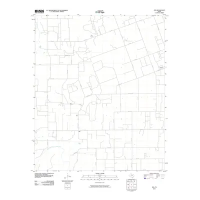
2010 Map of Jud
USGS Topo · Published 2010About this map
Jud sits at the center of this rural Haskell County landscape, where the agricultural grid is punctuated by local energy production and historical burial grounds. The extraction economy is clearly visible through the Julian Oil Field in the north and the Jud Oil Field just west of the main settlement. These sites reflect the region's long-standing reliance on mineral wealth alongside its ranching and farming roots. Water sources define the southern and western boundaries, with the Double Mountain Fork Brazos River winding across the lower half of the sheet to meet the primary Brazos River. Local family and community history is anchored by the Rochester Cemetery and the Idella Cemetery, while a network of rural roads like Carothers Ave and Cemetery Rd connects the scattered homesteads of this West Texas prairie.
Find a feature on this map
30 named features on this map. Tap any name to fly to it.
Don’t see what you’re looking for? This feature index may not catch every label — zoom into the map to look around manually.
Map Details
Editions of this 2010 Jud Map
This is the sole edition of this map. No revisions or reprints were ever made.
Other maps of this area

1925 · Aspermont 4-a
USGS Topo · 1:48,000

1925 · Haskell 3-b
USGS Topo · 1:48,000

1931 · Aspermont
USGS Topo · 1:62,500

1954 · Lubbock
USGS Topo · 1:250,000

1954 · Wichita Falls
USGS Topo · 1:250,000

1958 · Wichita Falls
USGS Topo · 1:250,000

1962 · Kiowa Peak
USGS Topo · 1:24,000

1965 · Jud
USGS Topo · 1:24,000
1966 · Pinkerton
USGS Topo · 1:24,000

1967 · Rochester
USGS Topo · 1:24,000