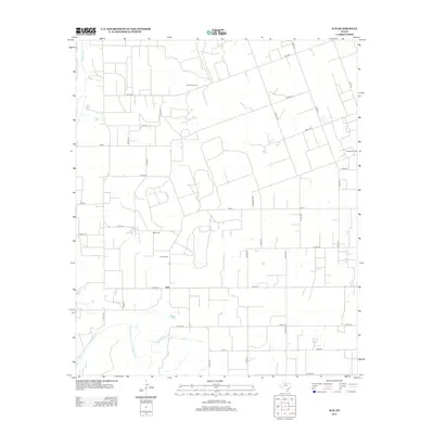
2013 Map of Jud
USGS Topo · Published 2013About this map
The Double Mountain Fork Brazos River winds through this West Texas landscape, joining with the Brazos River in the northwest corner of the quadrangle. This rural expanse in Haskell County is defined by its agricultural and industrial character, with the small settlement of Jud serving as a central point of reference. The region's economic history is evident in the presence of the Julian Oil Field and Jud Oil Field, which speak to the area's energy production. Genealogists and local historians will find the locations of Idella Cem and Rochester Cem valuable for tracing family roots in this sparsely populated stretch of the Rolling Plains. The map also details an extensive network of farm-to-market roads and county routes, including Cemetery Rd and FM-617, which provide the infrastructure for the area's sprawling ranch and oil operations.
Find a feature on this map
36 named features on this map. Tap any name to fly to it.
Don’t see what you’re looking for? This feature index may not catch every label — zoom into the map to look around manually.
Map Details
Editions of this 2013 Jud Map
This is the sole edition of this map. No revisions or reprints were ever made.
Other maps of this area

1925 · Aspermont 4-a
USGS Topo · 1:48,000

1925 · Haskell 3-b
USGS Topo · 1:48,000

1931 · Aspermont
USGS Topo · 1:62,500

1954 · Lubbock
USGS Topo · 1:250,000

1954 · Wichita Falls
USGS Topo · 1:250,000

1958 · Wichita Falls
USGS Topo · 1:250,000

1962 · Kiowa Peak
USGS Topo · 1:24,000

1965 · Jud
USGS Topo · 1:24,000
1966 · Pinkerton
USGS Topo · 1:24,000

1967 · Rochester
USGS Topo · 1:24,000