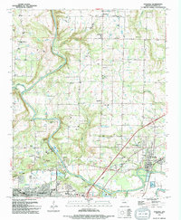
1994 Map of Judsonia
USGS Topo · Published 1994About this map
The Little Red River meanders through White County, anchoring a landscape defined by small communities and an extensive network of country churches. Small settlements like Plainview and Providence are hubs for rural life, while the city of Searcy and the town of Judsonia show the continued growth of the region into the 1990s. For genealogists, the map is particularly valuable for its documentation of numerous burial grounds including Evergreen Cem, Bethlehem Cem, and Knox Cem, alongside several rural congregations such as Berea Ch and Salem Ch.
Find a feature on this map
54 named features on this map. Tap any name to fly to it.
Don’t see what you’re looking for? This feature index may not catch every label — zoom into the map to look around manually.
Map Details
Editions of this 1994 Judsonia Map
This is the sole edition of this map. No revisions or reprints were ever made.
Other maps of this area

1932 · Kensett
USGS Topo · 1:62,500

1935 · Kensett
USGS Topo · 1:62,500

1935 · Bald Knob
USGS Topo · 1:62,500

1953 · Memphis
USGS Topo · 1:250,000

1956 · Memphis
USGS Topo · 1:250,000

1962 · Pangburn
USGS Topo · 1:24,000

1962 · Letona
USGS Topo · 1:24,000

1963 · Garner
USGS Topo · 1:24,000
1964 · Kensett
USGS Topo · 1:24,000
1964 · West Point
USGS Topo · 1:24,000