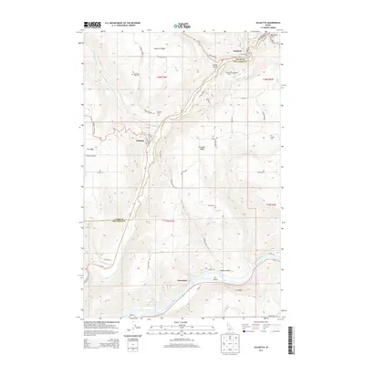
2013 Map of Juliaetta
USGS Topo · Published 2013About this map
Potlatch River canyon walls define the geography of this northern Idaho landscape, where the settlements of Kendrick and Juliaetta occupy the valley floor. The map documents the dramatic elevation shifts between the high, fertile agricultural grounds of American Ridge and Fix Ridge and the river basins below. This 2013 survey shows a high concentration of cemeteries including American Ridge Cem, Kendrick Cem, Juliaetta Cem, and Leland Cem, which serve as vital anchor points for local genealogical research. To the south, the terrain descends toward the confluence area near Cherrylane, where the river reaches the Clearwater River and its distinctive landforms like Fir Island and Fir Bluff. The network of gulches, including Brady Gulch and Hubbard Gulch, illustrates the complex drainage patterns that shaped the early road systems and property boundaries in this corner of Latah and Nez Perce Counties.
Find a feature on this map
59 named features on this map. Tap any name to fly to it.
Don’t see what you’re looking for? This feature index may not catch every label — zoom into the map to look around manually.
Map Details
Editions of this 2013 Juliaetta Map
This is the sole edition of this map. No revisions or reprints were ever made.
Other maps of this area

1955 · Pullman
USGS Topo · 1:250,000

1958 · Pullman
USGS Topo · 1:250,000

1958 · Lapwai
USGS Topo · 1:24,000

1958 · Lewiston Orchards
USGS Topo · 1:62,500

1958 · Culdesac
USGS Topo · 1:62,500

1960 · Troy
USGS Topo · 1:24,000

1961 · Kendrick
USGS Topo · 1:62,500

1961 · Moscow
USGS Topo · 1:62,500

1981 · Orofino
USGS Topo · 1:100,000

1981 · Potlatch
USGS Topo · 1:100,000