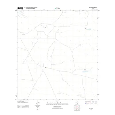
2013 Map of Julian
USGS Topo · Published 2013About this map
Julian sits as the central point of reference in this sparsely populated stretch of South Texas, where the landscape is defined by the vital infrastructure of ranching and water management. The terrain is notably flat, punctuated primarily by Candelaria Hill and the small catchments of Candelaria Lake. In an area where surface water is scarce, named water sources like Alto Bonito Windmill and Tio Hilario Windmill represent critical landmarks for local navigation and agricultural operations. The presence of Chaparrosa Camp suggests a continued reliance on seasonal or operational outposts typical of the large-scale ranching operations in Kenedy County. This document serves as a clear record of the rural road network and the strategic placement of these remote outposts as they appeared in the early 21st century.
Find a feature on this map
6 named features on this map. Tap any name to fly to it.
Don’t see what you’re looking for? This feature index may not catch every label — zoom into the map to look around manually.
Map Details
Editions of this 2013 Julian Map
This is the sole edition of this map. No revisions or reprints were ever made.
Other maps of this area

1922 · La Sal Vieja
USGS Topo · 1:62,500

1923 · Armstrong
USGS Topo · 1:62,500

1939 · Linn
USGS Topo · 1:62,500

1949 · Mc Allen
USGS Topo · 1:250,000

1953 · Brownsville
USGS Topo · 1:250,000

1954 · McAllen
USGS Topo · 1:250,000

1956 · Pita Camp
USGS Topo · 1:24,000
1956 · Armstrong
USGS Topo · 1:24,000

1956 · Julian
USGS Topo · 1:24,000

1956 · Rudolph
USGS Topo · 1:24,000