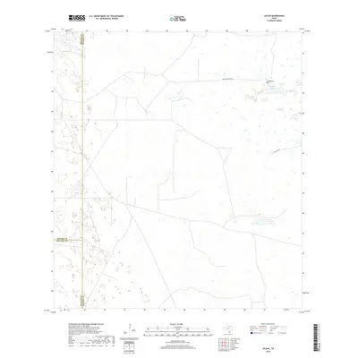
2019 Map of Julian
USGS Topo · Published 2019About this map
Candelaria Hill rises above the South Texas brushlands in this 2019 survey of the Julian quadrangle, where the borders of Kenedy, Brooks, and Hidalgo Counties converge. The landscape is defined by the ephemeral waters of Candelaria Lake and a series of smaller ponds and wetlands that dot the arid terrain. Human impact is visible through a network of ranch roads and boundary lines, including Tobin Armstrong Rd and S Tullidos Rd, which navigate the sparsely populated region. This survey captures the remote character of the ranching country north of the Rio Grande Valley, documenting the subtle shifts in elevation and the persistent water features that dictate the movement of cattle and commerce in this corner of the state.
Find a feature on this map
7 named features on this map. Tap any name to fly to it.
Don’t see what you’re looking for? This feature index may not catch every label — zoom into the map to look around manually.
Map Details
Editions of this 2019 Julian Map
This is the sole edition of this map. No revisions or reprints were ever made.
Other maps of this area

1922 · La Sal Vieja
USGS Topo · 1:62,500

1923 · Armstrong
USGS Topo · 1:62,500

1939 · Linn
USGS Topo · 1:62,500

1949 · Mc Allen
USGS Topo · 1:250,000

1953 · Brownsville
USGS Topo · 1:250,000

1954 · McAllen
USGS Topo · 1:250,000

1956 · Pita Camp
USGS Topo · 1:24,000
1956 · Armstrong
USGS Topo · 1:24,000

1956 · Julian
USGS Topo · 1:24,000

1956 · Rudolph
USGS Topo · 1:24,000