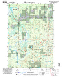
2005 Map of Jump River Fire Tower
USGS Topo · Published 2006About this map
Chequamegon - Nicolet National Forest dominates this northern Wisconsin landscape, revealing a mosaic of wetlands and timberland managed for conservation. The Jump River Fire Tower stands as a focal point for early forest management, situated near a series of Gravel Pits that suggest local road-building and resource extraction. The hydrology of the region is notably complex, defined by the Yellow River and its North Fork Yellow River, alongside significant water bodies like the Upper Steve Creek Flowage and the Upper Steve Creek Wetland Habitat Area. The southern portion of the map transition into the Ice Age Semi Primitive Non Motorized Area, a designation highlighting the geological heritage of the glacial terminal moraine. This 2005 revision preserves the boundary lines for Westboro and Grover, illustrating the intersection of civil townships and federal land use.
Find a feature on this map
22 named features on this map. Tap any name to fly to it.
Don’t see what you’re looking for? This feature index may not catch every label — zoom into the map to look around manually.
Map Details
Editions of this 2005 Jump River Fire Tower Map
This is the sole edition of this map. No revisions or reprints were ever made.
Other maps of this area

1944 · Ogema
USGS Topo · 1:48,000

1945 · Black River
USGS Topo · 1:48,000

1947 · Ogema
USGS Topo · 1:48,000

1949 · Ogema
USGS Topo · 1:48,000

1949 · Jump River Fire Tower
USGS Topo · 1:48,000

1951 · Lublin
USGS Topo · 1:48,000

1951 · Medford
USGS Topo · 1:48,000

1953 · Rice Lake
USGS Topo · 1:250,000

1959 · Rice Lake
USGS Topo · 1:250,000

1969 · Perkinstown
USGS Topo · 1:24,000