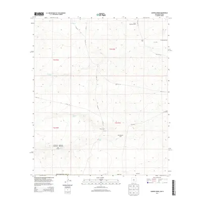
2013 Map of Jumping Spring
USGS Topo · Published 2013About this map
Jumping Spring serves as a vital water source in this arid corner of Eddy County, where the availability of water has long dictated the patterns of ranching and settlement. The landscape is defined by its drainages, such as South Hackberry Draw and Cottonwood Draw, which channel intermittent flows through the high desert. Ranching infrastructure is clearly evident through the presence of established holdings like Boone Beach Ranch and Dillahunty Ranch, alongside several wells and springs including Bailey Well and Washington Spring. This 2013 survey illustrates how modern county roads like Whites City Rd and Means Rd navigate the township and range lines of this portion of the Permian Basin, connecting isolated watering points and livestock operations across the complex topography of Hay Hollow.
Find a feature on this map
35 named features on this map. Tap any name to fly to it.
Don’t see what you’re looking for? This feature index may not catch every label — zoom into the map to look around manually.
Map Details
Editions of this 2013 Jumping Spring Map
This is the sole edition of this map. No revisions or reprints were ever made.
Other maps of this area

1945 · Carlsbad Caverns East
USGS Topo · 1:62,500

1945 · Malaga
USGS Topo · 1:62,500

1946 · Malaga
USGS Topo · 1:62,500

1947 · Carlsbad Caverns East
USGS Topo · 1:62,500

1954 · Carlsbad
USGS Topo · 1:250,000

1954 · Van Horn
USGS Topo · 1:250,000

1958 · Van Horn
USGS Topo · 1:250,000

1958 · Carlsbad
USGS Topo · 1:250,000

1973 · Owl Hills
USGS Topo · 1:24,000
1973 · Outlaw Spring
USGS Topo · 1:24,000