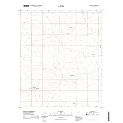
2020 Map of Jumping Spring
USGS Topo · Published 2020About this map
Jumping Spring and several other groundwater sources define this arid landscape in Eddy County, as it appeared in the early 21st century. The map reveals a network of intermittent water features and naming traditions tied to local history, such as Ben Slaughter Spring and the associated Ben Slaughter Draw. This area of the Pecos Valley watershed shows a distinct pattern of drainage through features like Cottonwood Draw and South Hackberry Draw, reflecting the essential nature of water in this high desert environment. The presence of Washington Spring and Butcher Spring suggests historically important watering points in an otherwise dry terrain. Transportation in the region is anchored by local routes such as Whites City Rd and Dillahunty Rd, which provide access through the complex topography of the North Fork Hay Hollow and South Fork Hay Hollow.
Find a feature on this map
32 named features on this map. Tap any name to fly to it.
Don’t see what you’re looking for? This feature index may not catch every label — zoom into the map to look around manually.
Map Details
Editions of this 2020 Jumping Spring Map
This is the sole edition of this map. No revisions or reprints were ever made.
Other maps of this area

1945 · Carlsbad Caverns East
USGS Topo · 1:62,500

1945 · Malaga
USGS Topo · 1:62,500

1946 · Malaga
USGS Topo · 1:62,500

1947 · Carlsbad Caverns East
USGS Topo · 1:62,500

1954 · Carlsbad
USGS Topo · 1:250,000

1954 · Van Horn
USGS Topo · 1:250,000

1958 · Van Horn
USGS Topo · 1:250,000

1958 · Carlsbad
USGS Topo · 1:250,000

1973 · Owl Hills
USGS Topo · 1:24,000
1973 · Outlaw Spring
USGS Topo · 1:24,000