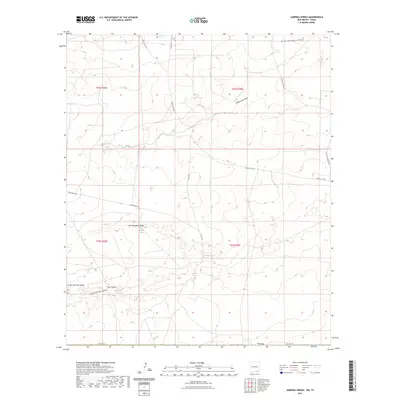
2023 Map of Jumping Spring
USGS Topo · Published 2023About this map
Jumping Spring and several other groundwater sources define the arid landscape of this southeastern New Mexico quadrangle. The map reveals a network of ephemeral watercourses including South Hackberry Draw, Cottonwood Draw, and Ben Slaughter Draw, which carve through the high desert terrain. These natural features are essential landmarks for understanding the area's hydrology and land use. Rural transit and land management are traced through a grid of local routes like Whites City Rd, Dillahunty Rd, and John D Forehand Rd. Names such as Ben Slaughter Spring and Washington Spring suggest a history of localized water reliance and ranching heritage within Eddy County. The map provides a detailed view of the sectional boundaries within the T25S and T26S townships, offering a clear picture of contemporary land divisions.
Find a feature on this map
27 named features on this map. Tap any name to fly to it.
Don’t see what you’re looking for? This feature index may not catch every label — zoom into the map to look around manually.
Map Details
Editions of this 2023 Jumping Spring Map
This is the sole edition of this map. No revisions or reprints were ever made.
Other maps of this area

1945 · Carlsbad Caverns East
USGS Topo · 1:62,500

1945 · Malaga
USGS Topo · 1:62,500

1946 · Malaga
USGS Topo · 1:62,500

1947 · Carlsbad Caverns East
USGS Topo · 1:62,500

1954 · Carlsbad
USGS Topo · 1:250,000

1954 · Van Horn
USGS Topo · 1:250,000

1958 · Van Horn
USGS Topo · 1:250,000

1958 · Carlsbad
USGS Topo · 1:250,000

1973 · Owl Hills
USGS Topo · 1:24,000
1973 · Outlaw Spring
USGS Topo · 1:24,000