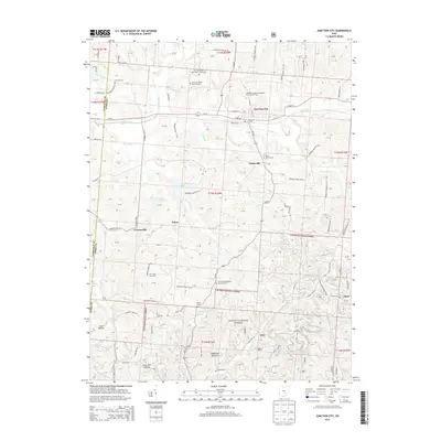
2013 Map of Junction City
USGS Topo · Published 2013About this map
Junction City serves as the primary hub of this Perry County landscape, situated at the convergence of several local drainages and road networks. The village layout is defined by streets like W Main St and E Main St, with its historical connection to the rails still evident near Railroad St. To the south and west, the map reveals a rugged terrain characterized by several named hollows, including Coon Hollow, Coalbrook Hollow, and Lime Kiln Hollow, reflecting the region's industrial and geological heritage. The southern reaches are largely encompassed by the Wayne National Forest, where smaller settlements like Dixie and Clarksville appear along the forest's edge.
Find a feature on this map
107 named features on this map. Tap any name to fly to it.
Don’t see what you’re looking for? This feature index may not catch every label — zoom into the map to look around manually.
Map Details
Editions of this 2013 Junction City Map
This is the sole edition of this map. No revisions or reprints were ever made.
Other maps of this area

1907 · Logan
USGS Topo · 1:62,500

1909 · Thornville
USGS Topo · 1:62,500

1909 · Logan
USGS Topo · 1:62,500

1910 · Zanesville
USGS Topo · 1:62,500

1911 · New Lexington
USGS Topo · 1:62,500

1947 · Columbus
USGS Topo · 1:250,000

1961 · Columbus
USGS Topo · 1:250,000

1961 · Rushville
USGS Topo · 1:24,000

1961 · New Lexington
USGS Topo · 1:24,000
1961 · New Straitsville
USGS Topo · 1:24,000