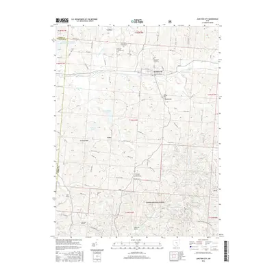
2016 Map of Junction City
USGS Topo · Published 2016About this map
Junction City serves as the primary hub of this Perry County landscape, situated at the convergence of several local transport routes including Main St and N Court St. The surrounding terrain is defined by a dense network of hills and hollows, such as Coon Hollow and Lime Kiln Hollow, which shape the paths of waterways like Rush Creek and Clark Run. The map reveals a deeply rooted rural community, marked by numerous religious landmarks and burial grounds including Saint Patricks Cem and the Friendship Methodist Episcopal Cem. Further south, the map extends into the Wayne National Forest, where the landscape becomes more wooded around Coalbrook Hollow. Smaller settlements and localities like Crossenville, Clarksville, and Salem are connected by a web of township and county roads, reflecting the long-established settlement patterns of this portion of Ohio.
Find a feature on this map
122 named features on this map. Tap any name to fly to it.
Don’t see what you’re looking for? This feature index may not catch every label — zoom into the map to look around manually.
Map Details
Editions of this 2016 Junction City Map
This is the sole edition of this map. No revisions or reprints were ever made.
Other maps of this area

1907 · Logan
USGS Topo · 1:62,500

1909 · Thornville
USGS Topo · 1:62,500

1909 · Logan
USGS Topo · 1:62,500

1910 · Zanesville
USGS Topo · 1:62,500

1911 · New Lexington
USGS Topo · 1:62,500

1947 · Columbus
USGS Topo · 1:250,000

1961 · Columbus
USGS Topo · 1:250,000

1961 · Rushville
USGS Topo · 1:24,000

1961 · New Lexington
USGS Topo · 1:24,000
1961 · New Straitsville
USGS Topo · 1:24,000