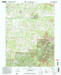
2002 Map of Junction City
USGS Topo · Published 2006About this map
Junction City serves as a hub of industry and infrastructure within the hills of Reading and Jackson townships. The landscape is heavily marked by extractive history, with numerous Strip Mines and Kilns clustered near the town center, while the Ohio State Penitentiary Junction City Branch occupies a significant footprint to the west. Outside the primary settlement, the terrain transitions into the heavily wooded Wayne National Forest, where smaller hamlets like Crossenville and Dixie remain connected by rural routes and family-named landmarks like Harvey Cem and Fairview Cem. A strong spiritual history is evident through the high density of country churches, including Mt Zion Ch, Old Zion Ch, and Friendship Ch, which dot the ridges above Rush Creek and Turkey Run.
Find a feature on this map
36 named features on this map. Tap any name to fly to it.
Don’t see what you’re looking for? This feature index may not catch every label — zoom into the map to look around manually.
Map Details
Editions of this 2002 Junction City Map
This is the sole edition of this map. No revisions or reprints were ever made.
Other maps of this area

1907 · Logan
USGS Topo · 1:62,500

1909 · Thornville
USGS Topo · 1:62,500

1909 · Logan
USGS Topo · 1:62,500

1910 · Zanesville
USGS Topo · 1:62,500

1911 · New Lexington
USGS Topo · 1:62,500

1947 · Columbus
USGS Topo · 1:250,000

1961 · Columbus
USGS Topo · 1:250,000

1961 · Rushville
USGS Topo · 1:24,000

1961 · New Lexington
USGS Topo · 1:24,000
1961 · New Straitsville
USGS Topo · 1:24,000