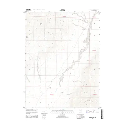
2014 Map of Junction Well
USGS Topo · Published 2014About this map
The Maverick Springs Range and Tognini Mountains define the high ground of this White Pine County landscape as it appeared in the early 21st century. The terrain is characterized by the broad expanse of Long Valley, where the drainage of the Long Valley Wash cuts through the desert floor. This region is a classic example of the Great Basin's basin-and-range topography, where isolated water sources were critical for early ranching and travel. Evidence of this survival-based geography is found at Junction Well, a vital point for those navigating the valley floor between the ranges. To the northeast, Cabin Spring marks another rare water point along the slopes, while the Butte Mountains rise to the southeast, illustrating the complex verticality of the Nevada desert.
Find a feature on this map
13 named features on this map. Tap any name to fly to it.
Don’t see what you’re looking for? This feature index may not catch every label — zoom into the map to look around manually.
Map Details
Editions of this 2014 Junction Well Map
This is the sole edition of this map. No revisions or reprints were ever made.
Other maps of this area

1955 · Elko
USGS Topo · 1:250,000

1956 · Ely
USGS Topo · 1:250,000

1958 · Elko
USGS Topo · 1:250,000

1959 · Ely
USGS Topo · 1:250,000

1962 · Elko
USGS Topo · 1:250,000

1963 · Ely
USGS Topo · 1:250,000

1965 · Elko
USGS Topo · 1:250,000
1968 · Ruby Lake SE
USGS Topo · 1:24,000
1969 · Station Butte
USGS Topo · 1:24,000
1982 · Junction Well
USGS Topo · 1:24,000