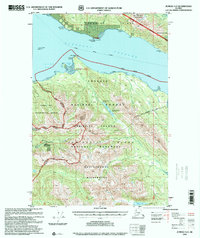
1996 Map of Juneau A-2
USGS Topo · Published 2000About this map
Stephens Passage separates the wilderness of Admiralty Island from the rugged terrain of Douglas Island in this coastal Alaskan landscape. The northern portion of the map is dominated by Douglas Island, featuring Mount Bradley (Mount Jumbo) and the historic Treadwell Ditch, which once supplied water to the famous mining operations nearby. The Marine Highway cuts through the passage, indicating the vital waterborne transit routes of the region.
Find a feature on this map
38 named features on this map. Tap any name to fly to it.
Don’t see what you’re looking for? This feature index may not catch every label — zoom into the map to look around manually.
Map Details
Editions of this 1996 Juneau A-2 Map
This is the sole edition of this map. No revisions or reprints were ever made.
Other maps of this area

1947 · Juneau B-3
USGS Topo · 1:63,360

1947 · Juneau B-2
USGS Topo · 1:63,360

1948 · Juneau A-3
USGS Topo · 1:63,360

1948 · Sitka D-1
USGS Topo · 1:63,360

1948 · Sitka D-3
USGS Topo · 1:63,360

1948 · Sitka D-2
USGS Topo · 1:63,360

1948 · Juneau B-1
USGS Topo · 1:63,360

1949 · Juneau B-3
USGS Topo · 1:62,500

1949 · Juneau B-2
USGS Topo · 1:62,500

1950 · Juneau A-3
USGS Topo · 1:63,360