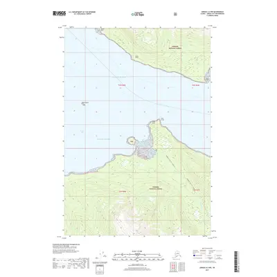
2017 Map of Juneau A-2 NW
USGS Topo · Published 2017About this map
The Tongass National Forest dominates this coastal landscape along the Gulf of Alaska, revealing a wilderness of steep contours and maritime landmarks. The shoreline is defined by prominent features such as Middle Point, Inner Point, and Point Hilda, which frame the entrance to protected waters. Inland, the map details the rugged passage from Admiralty Cove into the interior, specifically tracing the Admiralty Cove to N. Young Lk route. This path follows the drainage of Admiralty Cr, providing a critical link between the coast and the forested highlands. To the west, the isolated Scull Island sits in the open gulf, while Young Bay and Young Beach offer more sheltered coastal terrain. The map's focus on these specific points and portages underscores the importance of coastal navigation and established wilderness trails in the Juneau area.
Find a feature on this map
17 named features on this map. Tap any name to fly to it.
Don’t see what you’re looking for? This feature index may not catch every label — zoom into the map to look around manually.
Map Details
Editions of this 2017 Juneau A-2 NW Map
This is the sole edition of this map. No revisions or reprints were ever made.
Other maps of this area

1947 · Juneau B-3
USGS Topo · 1:63,360

1947 · Juneau B-2
USGS Topo · 1:63,360

1948 · Juneau A-3
USGS Topo · 1:63,360

1949 · Juneau B-3
USGS Topo · 1:62,500

1949 · Juneau B-2
USGS Topo · 1:62,500

1950 · Juneau A-3
USGS Topo · 1:63,360

1951 · Juneau
USGS Topo · 1:250,000

1951 · Juneau A-2
USGS Topo · 1:63,360

1962 · Juneau B-2
USGS Topo · 1:63,360

1962 · Juneau B-3
USGS Topo · 1:63,360