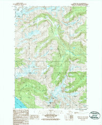
1986 Map of Juneau B-1 SW
USGS Topo · Published 1987About this map
The Gastineau Channel shoreline and the steep mountain ridges above Juneau define this mid-1980s topographic study. The settlement of Thane occupies a narrow strip of land between the water and the rising slopes of Roberts Peak, marked by industrial and maritime activity including a Fish Hatchery and Sub Sta. Further inland, the landscape is dominated by the massive Lemon Creek Glacier and Norris Glacier, illustrating the ice-bound character of the high country east of the city.
Find a feature on this map
37 named features on this map. Tap any name to fly to it.
Don’t see what you’re looking for? This feature index may not catch every label — zoom into the map to look around manually.
Map Details
Editions of this 1986 Juneau B-1 SW Map
This is the sole edition of this map. No revisions or reprints were ever made.
Other maps of this area

1947 · Juneau B-2
USGS Topo · 1:63,360

1948 · Juneau B-1
USGS Topo · 1:63,360

1949 · Juneau B-2
USGS Topo · 1:62,500

1951 · Juneau
USGS Topo · 1:250,000

1951 · Juneau A-2
USGS Topo · 1:63,360

1951 · Juneau A-1
USGS Topo · 1:63,360

1952 · Juneau B-1
USGS Topo · 1:63,360

1954 · Juneau A-1
USGS Topo · 1:63,360

1962 · Juneau B-2
USGS Topo · 1:63,360

1962 · Juneau
USGS Topo · 1:250,000