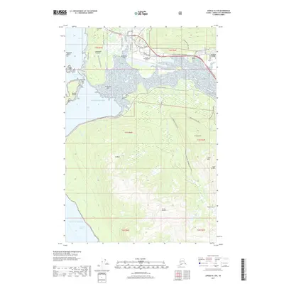
2017 Map of Juneau B-2 SW
USGS Topo · Published 2017About this map
Mendenhall Valley serves as a focal point for this 2017 study of Juneau's coastal and mountain landscapes, where modern infrastructure meets the complex glacial topography of the region. The Juneau International Airport dominates the low-lying wetlands north of Mendenhall Bar, while the residential and commercial areas of Sunny Point and Lemon Creek are framed by the Egan Drive/Glacier Highway corridor. The transition from tidal flats at Fritz Cove to the steep slopes of Douglas Island reveals a terrain defined by drainage systems like Fish Cr and Peterson Cr. Outdoor recreation and historic infrastructure are represented by the Treadwell Ditch Trail and Heintzleman Ridge Trail, which wind through the elevations of Mt Anderson and Mt Meek. This map provides a contemporary record of how the city's growth is constrained and directed by its dramatic geography.
Find a feature on this map
70 named features on this map. Tap any name to fly to it.
Don’t see what you’re looking for? This feature index may not catch every label — zoom into the map to look around manually.
Map Details
Editions of this 2017 Juneau B-2 SW Map
This is the sole edition of this map. No revisions or reprints were ever made.
Other maps of this area

1947 · Juneau B-3
USGS Topo · 1:63,360

1947 · Juneau B-2
USGS Topo · 1:63,360

1948 · Juneau A-3
USGS Topo · 1:63,360

1949 · Juneau B-3
USGS Topo · 1:62,500

1949 · Juneau B-2
USGS Topo · 1:62,500

1950 · Juneau A-3
USGS Topo · 1:63,360

1951 · Juneau
USGS Topo · 1:250,000

1951 · Juneau A-2
USGS Topo · 1:63,360

1962 · Juneau B-2
USGS Topo · 1:63,360

1962 · Juneau B-3
USGS Topo · 1:63,360