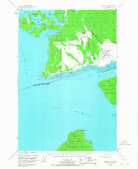
1948 Map of Juneau B-6
USGS Topo · Published 1967About this map
The settlement of Gustavus serves as the focal point of this coastal survey, situated on a flat plain between the Salmon River and the waters of Icy Passage. In the late 1940s, the area's infrastructure was dominated by the Gustavus Airfield, complete with a Communication Bldg, Powerhouse, and various radio towers. This aviation hub was crucial for navigating the coastal wilderness, where land and sea are intricately linked through features like the Seaplane Base at Bartlett Cove.
Find a feature on this map
36 named features on this map. Tap any name to fly to it.
Don’t see what you’re looking for? This feature index may not catch every label — zoom into the map to look around manually.
Map Details
Editions of this 1948 Juneau B-6 Map
4 editions found
Other maps of this area

1948 · Juneau C-5
USGS Topo · 1:63,360

1948 · Juneau B-6
USGS Topo · 1:63,360

1948 · Juneau C-6
USGS Topo · 1:63,360

1948 · Juneau B-5
USGS Topo · 1:63,360

1948 · Mount Fairweather B-1
USGS Topo · 1:63,360

1948 · Mount Fairweather A-1
USGS Topo · 1:63,360

1948 · Mount Fairweather C-1
USGS Topo · 1:63,360

1949 · Mount Fairweather C-1
USGS Topo · 1:63,360

1950 · Juneau C-6
USGS Topo · 1:63,360

1950 · Juneau B-5
USGS Topo · 1:63,360