
1948 Map of Mount Fairweather B-1
USGS Topo · Published 1957About this map
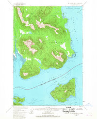
Glacier Bay National Monument dominates this coastal landscape, showing the transition between protected wilderness and the National Forest in the late 1940s. The map detail highlights the complex maritime environment where Icy Strait meets the southern entrance of Glacier Bay. In this era before widespread modernization, navigation relied on landmarks like Lemésurier Light on the north shore of Lemesurier Island.
Find a feature on this map
28 named features on this map. Tap any name to fly to it.
Don’t see what you’re looking for? This feature index may not catch every label — zoom into the map to look around manually.
Map Details
Editions of this 1948 Mount Fairweather B-1 Map
2 editions found
Other maps of this area

1948 · Juneau B-6
USGS Topo · 1:63,360

1948 · Juneau C-6
USGS Topo · 1:63,360

1948 · Mount Fairweather A-2
USGS Topo · 1:63,360

1948 · Mount Fairweather B-2
USGS Topo · 1:63,360

1948 · Mount Fairweather A-1
USGS Topo · 1:63,360

1948 · Mount Fairweather C-1
USGS Topo · 1:63,360

1948 · Mount Fairweather C-2
USGS Topo · 1:63,360

1949 · Mount Fairweather C-1
USGS Topo · 1:63,360

1950 · Mount Fairweather C-2
USGS Topo · 1:63,360

1950 · Juneau C-6
USGS Topo · 1:63,360