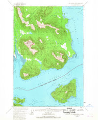
1948 Map of Mount Fairweather B-1
USGS Topo · Published 1967About this map
The coastal waters and mountainous shorelines of southeast Alaska are captured in this 1948 survey, showing a landscape defined by the intersection of Glacier Bay National Monument and the Tongass National Forest. The map focuses on the complex waterways of Icy Strait and Glacier Bay, where high-elevation landmarks like White Cap Mountain rise sharply from the coastline. A single Cabin located near the tidal flats of the Dundas River provides a lone indication of human activity in an area dominated by intricate maritime geography.
Find a feature on this map
29 named features on this map. Tap any name to fly to it.
Don’t see what you’re looking for? This feature index may not catch every label — zoom into the map to look around manually.
Map Details
Editions of this 1948 Mount Fairweather B-1 Map
2 editions found
Other maps of this area

1948 · Juneau B-6
USGS Topo · 1:63,360

1948 · Juneau C-6
USGS Topo · 1:63,360

1948 · Mount Fairweather A-2
USGS Topo · 1:63,360

1948 · Mount Fairweather B-1
USGS Topo · 1:63,360

1948 · Mount Fairweather B-2
USGS Topo · 1:63,360

1948 · Mount Fairweather A-1
USGS Topo · 1:63,360

1948 · Mount Fairweather C-1
USGS Topo · 1:63,360

1948 · Mount Fairweather C-2
USGS Topo · 1:63,360

1949 · Mount Fairweather C-1
USGS Topo · 1:63,360

1950 · Mount Fairweather C-2
USGS Topo · 1:63,360