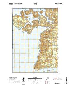
2017 Map of Juneau B-6 NW
USGS Topo · Published 2017About this map
Glacier Bay National Park dominates this landscape where the waters of Glacier Bay meet the shoreline at Point Gustavus. The map details a complex archipelago including the Beardslee Islands, Young Island, and Lester Island, which are separated from the mainland by the Beardslee Entrance and the protected waters of Bartlett Cove. This 2017 survey illustrates the managed transition between marine and terrestrial environments, marked by a network of footpaths near the cove. Notable routes such as the Tlingit Trail, Beach Trail, and Forest Trail provide access to the coastal forest, while the Bartlett River Trail and Bartlett Lake Trail follow the drainage of the Bartlett River inland. To the south, Ancon Rock stands as a maritime landmark near the southern tip of the peninsula.
Find a feature on this map
21 named features on this map. Tap any name to fly to it.
Don’t see what you’re looking for? This feature index may not catch every label — zoom into the map to look around manually.
Map Details
Editions of this 2017 Juneau B-6 NW Map
This is the sole edition of this map. No revisions or reprints were ever made.
Other maps of this area

1948 · Juneau B-6
USGS Topo · 1:63,360

1948 · Juneau C-6
USGS Topo · 1:63,360

1948 · Mount Fairweather B-1
USGS Topo · 1:63,360

1948 · Mount Fairweather C-1
USGS Topo · 1:63,360

1949 · Mount Fairweather C-1
USGS Topo · 1:63,360

1950 · Juneau C-6
USGS Topo · 1:63,360

1951 · Juneau
USGS Topo · 1:250,000

1951 · Mt Fairweather
USGS Topo · 1:250,000

1961 · Mt Fairweather
USGS Topo · 1:250,000

1962 · Juneau
USGS Topo · 1:250,000