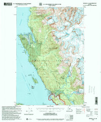
1996 Map of Juneau C-3
USGS Topo · Published 2000About this map
Glacial ice and industrial remnants define this coastal Alaskan landscape along the Favorite Channel and Berners Bay. The map documents a rugged transition where the Herbert Glacier and Eagle Glacier feed the Herbert River and Eagle River systems, carving deep basins like Yankee Basin and Cottrell Basin. The legacy of regional mining is evident at the Amalga (Site) and Eagle River Mine, while the Bessie Mine sits tucked near Yankee Cove. Recreation and maritime safety are represented by the Sentinel Island Lighthouse Reserve and several wilderness outposts, including the Windfall Lake Cabin (FS) and Boy Scout Camp. Infrastructure like the Veterans Memorial Highway and Glacier Highway provides the primary corridor through the Tongass National Forest, connecting historical prospects to the coastline at Eagle Beach.
Find a feature on this map
60 named features on this map. Tap any name to fly to it.
Don’t see what you’re looking for? This feature index may not catch every label — zoom into the map to look around manually.
Map Details
Editions of this 1996 Juneau C-3 Map
This is the sole edition of this map. No revisions or reprints were ever made.
Other maps of this area

1947 · Juneau B-3
USGS Topo · 1:63,360

1947 · Juneau B-2
USGS Topo · 1:63,360

1948 · Juneau B-4
USGS Topo · 1:63,360

1948 · Juneau C-4
USGS Topo · 1:63,360

1948 · Juneau D-3
USGS Topo · 1:63,360

1949 · Juneau B-3
USGS Topo · 1:62,500

1949 · Juneau B-2
USGS Topo · 1:62,500

1949 · Juneau D-4
USGS Topo · 1:63,360

1949 · Juneau C-4
USGS Topo · 1:63,360

1949 · Juneau D-3
USGS Topo · 1:63,360