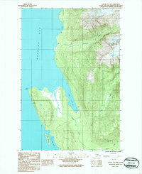
1986 Map of Juneau C-3 NW
USGS Topo · Published 1987About this map
Berners Bay defines the western coastline of this 1980s coastal survey, where the rugged shores of the Tongass National Forest meet the glacial waters of Southeast Alaska. The landscape is characterized by its dynamic tidal environments, specifically at Echo Cove and Bridget Cove, which are flanked by extensive Tidal Flats. This era of documentation shows the limited human footprint on the land, including a remote Landing Strip near the northern tip of the peninsula and a Gravel Pit located along the banks of Cowee Creek. The intersection of terrestrial and marine ecosystems is further marked by the Alaska Maritime National Wildlife Refuge, which encompasses the prominent Point Bridget and the small, nearby Mab Island. Watercourses like Sawmill Creek and Davies Creek drain the steep, forested elevations into the bay, illustrating the complex drainage patterns of this coastal wilderness.
Find a feature on this map
14 named features on this map. Tap any name to fly to it.
Don’t see what you’re looking for? This feature index may not catch every label — zoom into the map to look around manually.
Map Details
Editions of this 1986 Juneau C-3 NW Map
This is the sole edition of this map. No revisions or reprints were ever made.
Other maps of this area

1948 · Juneau C-4
USGS Topo · 1:63,360

1948 · Juneau D-3
USGS Topo · 1:63,360

1949 · Juneau D-4
USGS Topo · 1:63,360

1949 · Juneau C-4
USGS Topo · 1:63,360

1949 · Juneau D-3
USGS Topo · 1:63,360

1951 · Juneau
USGS Topo · 1:250,000

1951 · Juneau D-4
USGS Topo · 1:63,360

1951 · Juneau C-3
USGS Topo · 1:63,360

1952 · Juneau C-3
USGS Topo · 1:63,360

1953 · Juneau D-3
USGS Topo · 1:63,360