
1952 Map of Juneau C-3
USGS Topo · Published 1953About this map
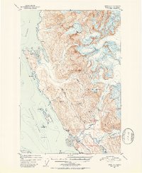
Eagle Glacier and Herbert Gl dominate the eastern reaches of this coastal survey, where massive ice fields feed a network of waterways including Eagle River and the Herbert River. The landscape is a study in resource extraction and navigation within the Tongass National Forest during the early 1950s. Industrial activity is centered around the Bessie Mine near Bessie Creek and the Eagle River Mine in the foothills. To the west, the maritime environment of Favorite Channel and Berners Bay is defined by hazardous rocks and small islands, with a Lighthouse stationed on Sentinel I to guide vessels. The Glacier Highway terminates in the south, giving way to the Montana Creek Trail, illustrating the era's reliance on trails and water routes for inland access toward Yankee Basin.
Find a feature on this map
33 named features on this map. Tap any name to fly to it.
Don’t see what you’re looking for? This feature index may not catch every label — zoom into the map to look around manually.
Map Details
Editions of this 1952 Juneau C-3 Map
2 editions found
Other maps of this area

1947 · Juneau B-3
USGS Topo · 1:63,360

1947 · Juneau B-2
USGS Topo · 1:63,360

1948 · Juneau B-4
USGS Topo · 1:63,360

1948 · Juneau C-4
USGS Topo · 1:63,360

1948 · Juneau D-3
USGS Topo · 1:63,360

1949 · Juneau B-3
USGS Topo · 1:62,500

1949 · Juneau B-2
USGS Topo · 1:62,500

1949 · Juneau D-4
USGS Topo · 1:63,360

1949 · Juneau C-4
USGS Topo · 1:63,360

1949 · Juneau D-3
USGS Topo · 1:63,360