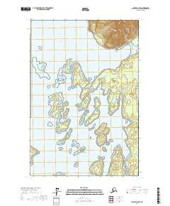
2017 Map of Juneau C-6 SW
USGS Topo · Published 2017About this map
Glacier Bay National Park encompasses this intricate coastal landscape in Southeast Alaska, where a labyrinth of islands and waterways defines the shoreline. The map reveals the southern reaches of Glacier Bay, including the sheltered waters of Beartrack Cove and the complex cluster of the Beardslee Islands. These islands, such as Kidney Island, Link Island, and Flapjack Island, are scattered across the Beardslee Entrance, illustrating the geological results of recent glacial retreat. On the eastern shore, the Bartlett River flows into the bay near Hutchins Bay. The absence of roads or permanent settlements emphasizes the wilderness character of this marine-dominated environment, providing an essential record for researchers studying shoreline changes and the glacial history of the Hoonah-Angoon Census Area.
Find a feature on this map
19 named features on this map. Tap any name to fly to it.
Don’t see what you’re looking for? This feature index may not catch every label — zoom into the map to look around manually.
Map Details
Editions of this 2017 Juneau C-6 SW Map
This is the sole edition of this map. No revisions or reprints were ever made.
Other maps of this area

1948 · Juneau B-6
USGS Topo · 1:63,360

1948 · Juneau C-6
USGS Topo · 1:63,360

1948 · Mount Fairweather B-1
USGS Topo · 1:63,360

1948 · Mount Fairweather C-1
USGS Topo · 1:63,360

1949 · Mount Fairweather C-1
USGS Topo · 1:63,360

1950 · Juneau C-6
USGS Topo · 1:63,360

1951 · Juneau
USGS Topo · 1:250,000

1951 · Mt Fairweather
USGS Topo · 1:250,000

1961 · Mt Fairweather
USGS Topo · 1:250,000

1962 · Juneau
USGS Topo · 1:250,000