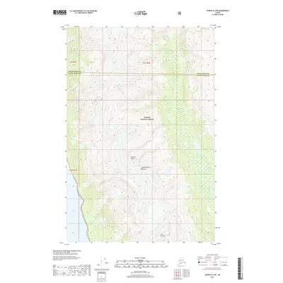
2017 Map of Juneau D-4 NE
USGS Topo · Published 2017About this map
The Kakuhan Range dominates this portion of the Coast Mountains within the Tongass National Forest, where the topography transitions from high alpine peaks to the riparian flats of the Berners River. This 2017 survey delineates the boundary between Haines Borough and Juneau Borough as it crosses a landscape defined by glacial influence and drainage patterns. Near the southern edge, Lions Head Mtn stands as a prominent landmark above the surrounding terrain. The presence of Independence Lake tucked into the western slopes illustrates the typical high-altitude catchment basins of this wilderness area. The map is primarily a record of natural hydrology and geomorphology, lacking significant human infrastructure, which highlights the remote character of this maritime forest environment in Southeast Alaska.
Find a feature on this map
11 named features on this map. Tap any name to fly to it.
Don’t see what you’re looking for? This feature index may not catch every label — zoom into the map to look around manually.
Map Details
Editions of this 2017 Juneau D-4 NE Map
This is the sole edition of this map. No revisions or reprints were ever made.
Other maps of this area

1948 · Juneau D-3
USGS Topo · 1:63,360

1948 · Skagway A-1
USGS Topo · 1:63,360

1949 · Atlin
USGS Topo · 1:250,000

1949 · Juneau D-4
USGS Topo · 1:63,360

1949 · Juneau D-3
USGS Topo · 1:63,360

1951 · Juneau
USGS Topo · 1:250,000

1951 · Skagway A-1
USGS Topo · 1:63,360

1951 · Atlin
USGS Topo · 1:250,000

1951 · Juneau D-4
USGS Topo · 1:63,360

1952 · Skagway
USGS Topo · 1:250,000